Major Important Strait of Asia
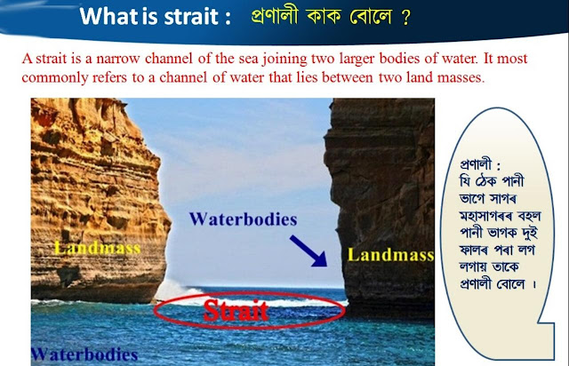
What is Strait:
A strait is a thin channel of a waterway that connects two large water bodies having some characteristics like –
Formed by natural processes
Narrower than the seas it connects
Navigable
It most commonly refers to a channel of water that lies between two land masses.
Major straits of the world are generally used by commercial shipping to travel from one sea or exclusive economic zone to another and they are of immense strategic and commercial importance. They also serve as a channel through which ocean currents pass modifying the climate of that area.
It is seen that In these reasons straits play an important role in physical and human geography.
Major Important Strait of Asia:
There are 7 major straits in Asia. These are –
1. The Bab el-Mandeb, or “Gate of Tears”.
2. Strait of Hormuz
3. Duncan Passage
4. The Korea Strait
5. Ten Degree Channel
6. Taiwan Strait
7. Qiongzhou Strait
1. The Bab el-Mandeb Strait :
The Bab el-Mandeb, or “Gate of Tears”, is a narrow neck of water that separates the Red Sea from the Indian Ocean. It’s bordered to the northeast by Yemen and to the southwest by Eritrea and Djibouti. The strait is divided into two channels by Perim Island. Larger vessels use the wider and deeper western channel, which at its narrowest point is around 25 kilometers wide and 170 fathoms (310 meters) deep. A smaller channel along the Yemeni coast is two miles wide. Shipping through Bab el-Mandeb is separated into inbound and outbound channels, each two miles wide. Bab el-Mandeb forms a vital link on the trade route between the Mediterranean and Asia. Vessels carrying goods between Europe and Asia, as well as oil from the Middle East to Europe and North America, pass through it if navigating Egypt’s Suez Canal.
2. Strait of Hormuz :
The Strait of Hormuz is the world's single most important oil passageway, forming a chokepoint between the Arabian Gulf and the Gulf of Oman. The 39km strait is the only route to the open ocean for over one-sixth of global oil production and one-third of the world's liquified natural gas (LNG).
It lies between Oman and Iran, linking the sea passage from the countries on the Gulf (Iraq, Kuwait, Saudi Arabia, Bahrain, Qatar and the United Arab Emirates) with the Arabian Sea and beyond.
Although the narrowest point in the strait is just 33km wide, the shipping lanes in both directions are only 3km wide. Traveling by sea, the strait is the only means of transporting goods or people to the rest of the world. Around one-sixth of the world’s oil moves through the strait - 17.2 million barrels per day. This includes most of the oil from Organization of Petroleum Exporting Countries (OPEC) members Saudi Arabia, Iran, the UAE and Kuwait. Qatar, the world’s biggest exporter of LNG, sends most of its LNG through the strait as well.
3. Duncan Passage:
Duncan Passage is located between Little Andaman and Car Nicobar Island. Duncan Passage is a strait in the Indian Ocean. It is about 48 km (30 mi) wide; it separates Rutland Island (part of Great Andaman) to the north, and Little Andaman to the south.
4.The Korea Strait :
The Korea Strait separates South Korea and Japan. The sea passage extends northeast from the East China Sea to the Sea of Japan. Tsushima Island bisects the strait, dividing it into the Western and the Eastern Channel. The Eastern Channel is commonly known as the Tsushima Strait. The Korea Strait is bound in the north by the Korean Peninsula’s southern coast and to the south by the Japanese Islands of Honshu and Kyushu. The Korea Strait is about 120 miles wide. Its average depth is 300 feet. However, the western channel is narrower and deeper compared to the Tsushima Strait. The Tsushima Current, which is a warm branch of the Kuroshio Current, passes through the Korea Strait.
5. Ten Degree Channel :
The Ten Degree Channel is a channel that separates the Andaman Islands and Nicobar Islands from each other in the Bay of Bengal. Ten degrees Channel which lies between Little Andaman Island and the Car Nicobar, about 77 miles to the South , is deep and clear. The Channel is approximately 150 km wide, running essentially along an east-west orientation. It is so named as it lies on the 10-degree line of latitude, north of the equator. A depth of 7.3m lies 4 miles S of Sandy Point, the SW point of Little Andaman Island.
6. Taiwan Strait :
The Taiwan Strait is a 180-kilometer wide strait separating the island of Taiwan from mainland China. The strait is currently classified as part of the South China Sea and borders the East China Sea to the north. It is 130 km wide at its narrowest.
Taiwan Strait, also called Formosa Strait, which is extends from southwest to northeast between the South and East China seas. It reaches a depth of about 230 feet and contains the Pescadores Islands (which are controlled by the government of Taiwan). The strait was named Formosa (“Beautiful”) by Portuguese navigators in the late 16th century; although it is still known in the West by its European name, the Chinese and now most Westerners use the name Taiwan Strait.
7. Qiongzhou Strait:
Qiongzhou Strait is located at 20°N, 109°–111°E and it is a narrow ocean passage connecting the Gulf of Beibu (Gulf of Tonkin) on the west and the northeastern South China Sea (SCS) Basin on the east . The strait is about 70 km long and 30 km wide, with a maximum depth of 120 m. This is a dynamic coastal region characterized by complex physical processes. Tidal waves, which are dominated by diurnal constituents on the western side and by semidiurnal constituents on the eastern side, propagate toward Qiongzhou Strait from the Gulf of Beibu and decrease significantly in amplitude in the strait.


Comments
Post a Comment