MERCATORS PROJECTION AND THE MAJOR INTERNATIONAL SEA ROUTES
INTRODUCTION:
The Mercator projection
was originally developed by the Flemish cartographer Gerardus Mercator in 1569.
Mercator projection is a method of creating a rectangular flat map with a grid
of vertical lines representing longitude lines and horizontal lines
representing latitude. Surface land and water areas of the nearly spherical
Earth are “unwrapped” from the globe. stretched (actually “plotted”), and
projected onto a cylinder whose diameter is coincident with the equator. The
central axis of the cylinder aligns with the axis of the earth. The projected
cylindrical map is unfurled to created the flat rectangular wall maps we are
all familiar with. This conceptual interpolated map is scaled down to a
practical scale so it becomes a useable tool for navigation and a long list of
other geopolitical functions.
In the ancient time, many of Europe’s top cartographers and
explorers used elliptical projections derived from Ptolemy’s latitude and
longitude grid. Although accurate, these projections were difficult for
navigators and explorers to use because they required that bearing constantly
be recalculated as they moved (Stockton, 2013).
Maps created prior to Mercator’s that were drawn on Ptolemy’s
grid showed that each degree of latitude or longitude was the same size. As a
result sailor’s rhumb lines (straight lines on the Earth used by navigators that
follow a single compass bearing) curved and navigators would have to
recalculate their bearing as they moved to account for the change (Israel,
2003).

FAMOUS WORLD MAP OF 1569
MERIT
OF THIS PROJECTION:
1- Explore the world
Before
Mercator's projection, there were already maps showing the full extent of
planet Earth. However,
this was the first that provided people with the means to explore and navigate
across the seas. Mainly, this projection is useful for tracing routes with a
steady course in a straight line.
In
addition to creating a projection, Mercator published a geometric formula that
corrected the distortion presented on its map. These calculations enabled
seafarers to transform projection measurements into degrees of latitude by
facilitating navigation.
Like
any flat rendering of the Earth, Mercator's projection presents distortion. The
globe is the only true representation of the earth's surface.
In
spite of this, the fact that these are so small makes them impractical for
navigation. For this reason, the projection of Mercator is still preferred.
2- Calculations of this projection
are simpler than those of other projections
The
mathematics behind the Mercator projection are much simpler than other
projections today. For this reason, online mapping services prefer its use.
The
applications of Google Maps, Bing Maps and OpenStreetMaps are based on Mercator
projection.
3- Keep the scales
The
projection of Mercator is proportional. This means that to compensate for the
north-south distortion (from pole to pole), an east-west distortion is also
introduced.
Other
projections can make a square building look rectangular, because the distortion
exists in only one direction.
On
the other hand, because it is proportional, the distortion generated by
Mercator does not make the objects appear more elongated or flattened, but
simply larger.
This
is another reason why the cartography web services use this type of projection
and not others.
4- Angles are represented
correctly
The
projection of Mercator has the property of representing the angles as they are.
If in the real plane there is an angle of 90 ° the projection will show an
angle of the same amplitude.
This
is another reason why Google Maps and other similar applications prefer
Mercator before other projections.
DEMERITS OF THE PROJECTION:
1- Distortion of the Earth's
surface
As
Mercator's projection moves away from the equator, the representation of the
Earth's surface is distorted. This distortion makes the shapes found at the
poles look bigger than they really are.
Mercator's
projection shows that Greenland is the size of Africa, that Alaska is larger
than Brazil and that Antarctica is an infinite expanse of ice.
In
fact, Greenland is the size of Mexico, the territory of Alaska is 1/5 that of
Brazil and Antarctica is a little larger than Canada.
As
a result, business charts for educational purposes often do not employ Mercator
projection, so as not to create problems in the student learning process.
However, they are still used in the representation of areas near Ecuador.
2- Polar zones are not represented
Because
the projection of Mercator is based on a cylinder, it is difficult to represent
the polar zones of the planet Earth. For this reason, the poles are not
included in this type of cartographic projection.
EXERCISE:
Draw a graticules on Mercator’s projection of scale 1:175,000,000 and interval 15˚
and show there in the major international sea routes.
2. INSTRUCTION: According to the assignment -
Radious
of the reduce earth is R.F.=
250,000,000/175,000,000 = 1.43 //
The
length of the horizontal straight line is 2πR = 2×3.1416×1.43
= 8.98˝ . It is represent as equator.
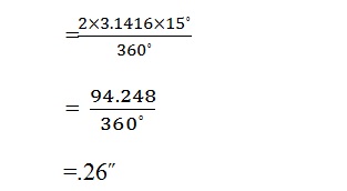
The interval between the meridian = 2πR × Interval/360˚
The interval between the meridian = 2πR × Interval/360˚
Distance of any parallel (ɸ˚) from the equator. If Y is the distance between the equator of any selected parallel (ɸ˚) than it can be expressed with the help of different equation.

dy = R Sec ɸ.d ɸ
y = ∫ R Sec ɸ.d ɸ
= R log tan 45˚+ ɸ˚/2
= 2.3026 R log tan (45+ ɸ˚/2)

in summary, the Mercator projection...
- Is a cylindrical projection.
- Has the equator or two symmetrical latitudes serve as lines of contact.
- Is conformal and represents small shapes well due to angular relationships.
- Preserves direction and lines represent accurate compass bearings.
- Preserves scale along equator with increasing area distortion closer to the poles, which cannot be displayed.


Well... Helpful
ReplyDeleteThank you so much .
DeleteThank you so much .
DeleteThank you so much .
ReplyDeleteMost welcome
DeleteSuch a well-written post! You’ve made a complex subject feel approachable and easy to understand.
ReplyDeletewooden world map